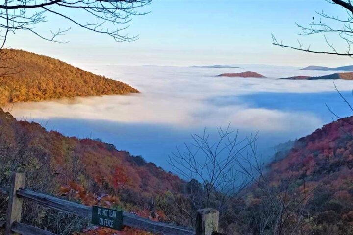
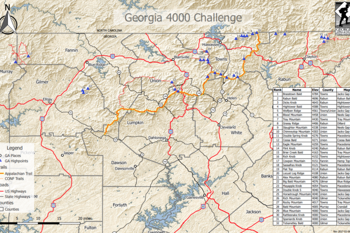
Georgia 4000
4000 Foot Peaks
Peak Selection Criteria
- The summit must be at least 4,000 feet in elevation
- The summit must have 120 feet of clean prominence. This means there must be at least 120 feet from the key saddle (lowest point) connecting the intermediate summit to a higher summit. Clean prominence of 120 feet could mean as much as 200 feet of actual prominence if the summit is 40 feet higher than the last closed contour line and the saddle is 40 feet lower than the last closed contour line.
- No specific isolation criteria was used. However, each peak is at least a half mile distant from the summit of the nearest qualifying peak.
The result is the list of 32 peaks below. The source for prominence is US Topo which is an extract of the National Map by the USGS with the Georgia update of 2014.
Brasstown Bald - 4,784 ft.
Land Area: Brasstown Wilderness
Trail(s): Paved walking trail from parking lot.
Notes: NatGeo incorrectly shows 4668 ft elevation
Rabun Bald - 4,696 ft.
Land Area: Warwoman WMA
Trail(s): Bartram (FS164), Rabun Bald (FS211)
Notes: Old stone tower with wooden viewing platform on top
Dicks Knob - 4,643 ft.
Land Area: S Nantahala Wilderness
Trail(s): Bushwhack
Notes: Nearby Little Bald is just north in NC and is over 5040 ft. USGS TopoQuest and USGS US Topo does not show 4640 line (elev may be overstated)
Hightower Bald - 4,588 ft.
Land Area: S Nantahala Wilderness
Trail(s): Bushwhack
Notes: Montgomery Corner – small deviation in GA/NC border. Many sources list elev of 4568
Unnamed - Wolfpen Ridge (south) - 4,561 ft.
Land Area: Brasstown Wilderness
Trail (s): Jacks Knob Trail (FS45)
Notes: NatGeo incorrectly shows 4668 elevation, summit is just off of trail. Clean prominence of 200
Blood Mountain - 4,458 ft.
Land Area: Blood Mtn Wilderness
Trail(s): AT
Notes: Stone shelter on top. Vogel State Park shows 4458
Tray Mountain - 4,430 ft.
Land Area: Tray Mtn Wilderness
Trail(s): AT
Notes: Trail crosses peak
Grassy Ridge - 4,406 ft.
Land Area: S Nantahala Wilderness
Trail(s): Near old Grassy Ridge Trail
Notes: Short bushwhack
Slaughter Mountain - 4,338 ft.
Land Area: Blood Mtn Wilderness
Trail(s): Near Duncan Ridge (FS4), Coosa Backcountry (FS111)
Notes: Short bushwhack (nearby trail is both Duncan Ridge (4) and Coosa Backcountry (111))
Chimneytop Mountain (Arkaquah) - 4,303 ft.
Land Area: Brasstown Wilderness
Trail(s): Arkaquah (FS29)
Notes: Clean prominence of 120ft add 23ft from summit to last elev line = 143. Short path to summit from trail
Double Spring Knob - 4,276 ft.
Land Area: Swallow Creek WMA
Trail(s): Near AT
Notes: Short bushwhack. USGS TopoQuest shows 4280 line
Coosa Bald - 4,271 ft.
Land Area: Cooper Creek WMA
Trail(s): Duncan Ridge (FS4)
Notes: Trail crosses peak. USGS TopoQuest shows 4280 line. Vogel State Park shows 4271
Eagle Mountain - 4,259 ft.
Land Area: S Nantahala Wilderness
Trail(s): Bushwhack
Notes: Old trail from Bell Gap
Flint Knob - 4,240 ft.
Land Area: Chattahoochee NF
Trail(s): Bushwhack from old trail near Alex Gap
Notes: No actual summit elev measured and 120ft clean prominence. NW half of mountain is private land
Brier Creek Bald - 4,163 ft.
Land Area: Swallow Creek WMA
Trail(s): Near AT & Near FS road 698
Notes: Short bushwhack
Rich Knob - 4,152 ft.
Land Area: S Nantahala Wilderness
Trail(s): Near AT
Notes: Short bushwhack from GA/NC border on AT
Cowpen Mountain - 4,151 ft.
Land Area: Cohutta Wilderness
Trail(s): Near East Cowpen Trail (FS30)
Notes: Short bushwhack
Sassafras Knob - 4,121 ft.
Land Area: S Nantahala Wilderness
Trail(s): Bushwhack
Notes: Access the area from Egypt Gap
Flat Top - 4,114 ft.
Land Area: Warwoman WMA
Trail(s): Near Bartram (FS164)
Notes: Short bushwhack
Unnamed - Locust Ridge - 4,108 ft.
Land Area: Brasstown Wilderness
Trail(s): Near Arkaquah Trail (FS29)
Notes: Clean prominence of 120ft add 28ft from summit to last elev line = 148. May also be called Blue Bluff. Short bushwhack
Alex Mountain - 4,080 ft.
Land Area: Chattahoochee NF
Trail(s): Road walk on Bayberry Lane or Wild Bird Way
Notes: NE half of mountain is private land
Big Bald Mountain - 4,076 ft.
Land Area: Rich Mtn Wilderness
Trail(s): Near FS road 338
Notes: Bushwhack. USGS TopoQuest shows 4075 – NatGeo likely raised this after the 1988 North American Vertical Datum adjustment
Mayapple Knob - 4,054 ft.
Land Area: S Nantahala Wilderness
Trail(s): Bushwhack
Notes: Very remote. Faint path connects with Sassafras and Rattlesnake
Double Knob (South Peak) - 4,040 ft.
Land Area: Brasstown Wilderness
Trail(s): Near Wagon Train Trail (FS44)
Notes: Long and difficult bushwhack. US Topo notes 4000 contour line only while USGS TopoQuest shows 4040 at South Peak
Horsetrough Mountain - 4,040 ft.
Land Area: Mark Trail Wilderness
Trail(s): AT Access
Notes: Long bushwhack
Rich Mountain - 4,040 ft.
Land Area: Rich Mtn Wilderness
Trail(s): Near FS road 338
Notes: Bushwhack, old tower foundation on top
Rocky Mountain - 4,017 ft.
Land Area: Swallow Creek WMA
Trail(s): AT
Notes: Summit just off trail in camping area
Bald Mountain - 4,005 ft.
Land Area: Cohutta Wilderness
Trail(s): Tearbritches Trail (FS9)
Notes: Little Bald Mtn overlook and Grassy Mtn tower are good nearby hikes
Blue Mountain - 4,000 ft.
Land Area: Mark Trail Wilderness
Trail(s): AT
Notes: Trail crosses peak
Rattlesnake Knob - 4,000 ft.
Land Area: S Nantahala Wilderness
Trail(s): Bushwhack
Notes: NatGeo incorrectly shows 3960 elevation
Spaniards Knob - 4,000 ft.
Land Area: Mark Trail Wilderness
Trail(s): AT access
Notes: Long bushwhack, double summit with neither clearly higher (hike both)
Tickanetley Bald - 4,000 ft.
Land Area: Rich Mtn Wilderness
Trail(s): Near FS road 338
Notes: Old trail from FS road 338 just west of Rich Mtn
Other High Areas
- Chimney Top (North on Wolfpen Ridge – elev 4117). Clean prominence of only 80ft add 37ft from summit to last elev line = 117. Does not qualify.
- Little Bald Mtn (4400 elev) north of Brasstown Bald. No actual summit elev measured and 80ft clean prominence. Does not qualify.
- Unnamed summit (4400 elev) between Flint Knob and Rabun Bald. No actual summit elev measured and 80ft clean prominence. Does not qualify.
- Rocky Mtn and other Brasstown adjoining ridges
- Shooting Creek Bald near Hightower Bald